
Did you know that hundreds of barangays across Metro Manila are classified as flood-prone, according to the Department of Public Works and Highways (DPWH) and the Metro Manila Development Authority (MMDA)? With the capital’s rapid urbanization, aging drainage systems, and changing rainfall patterns, flooding has become one of the most persistent threats to homeowners and property investors.
Buying property without checking flood risk is no longer an oversight—it’s a gamble. Even prime locations can face recurring water buildup or drainage issues that quietly erode property values over time. Whether you’re a first-time buyer, a long-term investor, or simply choosing a safer place for your family, understanding the flood dynamics of Metro Manila is essential.
This guide reveals the top five flood-risk zones, backed by verified data from DPWH, PAGASA, and MMDA, and explains how to read official flood maps, evaluate property risks, and find safer, flood-resilient alternatives within the metro.
Because in Metro Manila, smart buying isn’t just about finding the right location—it’s about securing the right elevation.
Understanding Flood Risk in Metro Manila
Flooding isn’t new to Metro Manila—but its frequency, reach, and cost have grown dramatically over the past two decades. Before identifying the city’s top flood-prone zones, it’s vital to understand what drives the problem and how the government measures flood risk across the region.
What Causes Flooding in Metro Manila?
Metro Manila sits on a low-lying floodplain intersected by major rivers and creeks, including the Pasig, Marikina, and Tullahan Rivers. These natural waterways are crucial drainage channels—but rapid urbanization has choked them.
Urban Overdevelopment
Continuous construction of concrete surfaces leaves rainwater with nowhere to go. Green spaces and soil that once absorbed rainfall have been replaced by roads and buildings.
Clogged Waterways
Informal settlements and waste accumulation block drainage canals and esteros, leading to water backflow even after short bursts of rain.
Aging Drainage Systems
Many of Metro Manila’s drainage lines date back to the 1970s and were not built for today’s population or rainfall intensity.
Climate Change and Rainfall Patterns
PAGASA reports heavier and more erratic rainfall, with typhoons now producing record-high precipitation levels that overwhelm city systems.
Government Flood Classifications
The Department of Public Works and Highways (DPWH) and the Metro Manila Development Authority (MMDA) maintain official Flood Hazard Maps that classify areas according to susceptibility levels:
Low Flood Susceptibility
Flooding less than 0.5 meter deep, usually short-lived.
Moderate Flood Susceptibility
Flood depth between 0.5 to 1.5 meters, lasting several hours to a day.
High Flood Susceptibility
Flooding more than 1.5 meters deep and lasting more than a day, often requiring evacuation.
You can verify your area’s flood category through the DPWH GeoRiskPH platform or MMDA’s Flood Control and Sewerage Management Office (FCSMO) data, which provides barangay-level maps for public reference.
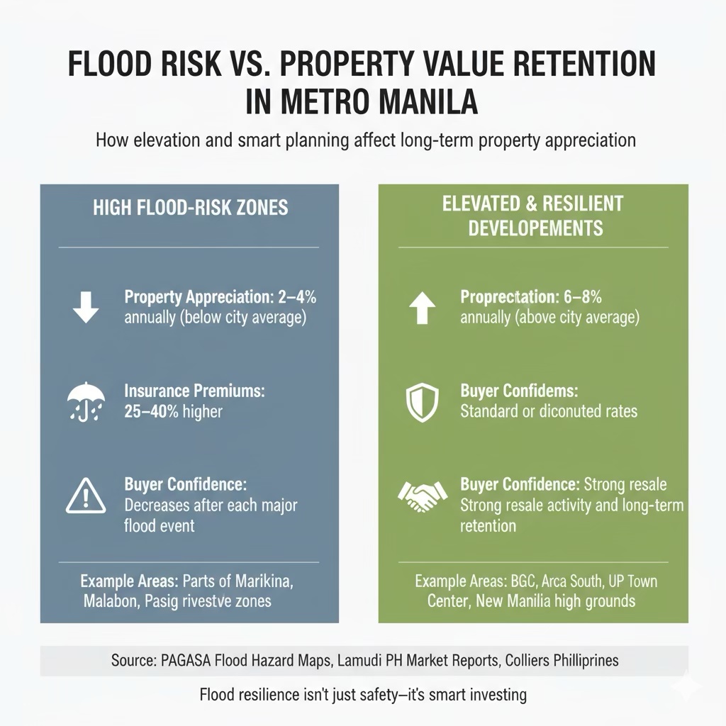
Impact on Real Estate and Property Values
Flood risk directly influences property value, insurance, and resale potential.
Depreciation
Homes in flood-prone zones often sell at a discount relative to properties in safer areas.
Insurance Costs
Premiums rise with flood exposure, especially for ground-level or basement structures.
Resale Challenges
Even minor flood incidents can affect buyer confidence, with online listings and local news making past events easy to trace.
Smart developers are now adapting through elevated podium designs, stormwater retention systems, and landscape drainage integration, but buyers should still review a project’s flood certification and surrounding terrain before committing.
The Top 5 Flood-Risk Zones in Metro Manila – What Every Buyer Must Know
Each of the five profiles below includes a mini data table, local context, and a real-estate-buyer insight. Use them as quick-reference risk flags when evaluating a property.
1️⃣ Malabon City
| Metric | Key Detail |
|---|---|
| Elevation / terrain | Described as a “natural catch basin” due to its low-lying flat terrain and proximity to the Tullahan River. |
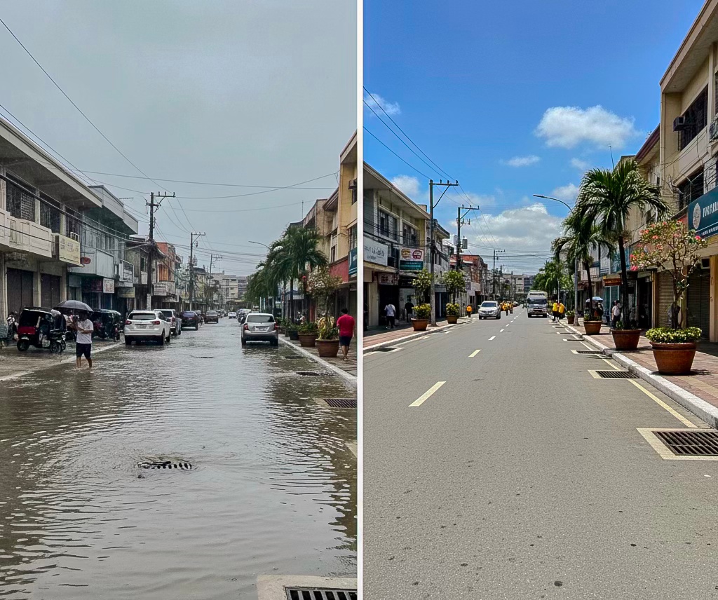
| Flood incidents | July 2025: knee-deep floods reported in Barangay Tonsuya when heavy monsoon rains hit. |
| Mitigation activity | City placing 505 sandbags in key barangays and declogging major drainage canals. |
| Real-estate implication | Land prices are generally lower compared to higher-elevation Metro Manila zones — but expect higher insurance or flood mitigation costs. |
Malabon is one of the most flood-vulnerable cities in Metro Manila. Its very flat terrain, proximity to major waterways, and tidal influence mean that even moderate rainfall or a high tide can lead to inundation. Research identifies Malabon as one of the cities most exposed to flooding and sea-level rise.
Buyer Insight
If you’re considering Malabon, go deep on elevation of the lot (above base flood level), ask for flood-history by barangay, and budget for flood-resilience upgrades (e.g., elevated floor, flood-proofing). Lower cost doesn’t mean low risk.
2️⃣ Navotas City
| Metric | Key Detail |
|---|---|
| Geographic exposure | Coastal city adjacent to Manila Bay, with tidal-flooding and land-subsidence risks evident. |
| Incidents | June 2025: several streets flooded (4-7 inches) during high-tide event; flood wall breach reported. |
| Real-estate implication | Reclaimed zones and littoral lots may appear attractive — but are among the highest risk for tidal influx and subsidence. |
Why Navotas makes the list
Navotas bears a dual risk: coastal/tide flood exposure and river/rainfall flooding (due to river overflow or drainage issues). The June 2025 incident underlines how even modest tidal surges can flood urban streets.
Buyer Insight
When inspecting a property in Navotas:
- Check whether the site is reclaimed land (and elevation above sea-level).
- Ask for engineered flood-barrier details (sea-wall, river-wall).
- Factor in likely higher maintenance/flood-mitigation cost even if purchase price is lower.
3️⃣ Caloocan City
| Metric | Key Detail |
|---|---|
| Latest event | July 2025: City declared a state of calamity after ~50,000 families affected by severe rains/flooding. |
| Flood driver | Overflow of Tullahan River and aged drainage system in many barangays. |
| Real-estate implication | Northern Caloocan (higher ground) less exposed than southern, river-adjacent zones. Buyer segmentation essential. |
Why Caloocan is high-risk
Caloocan’s flood profile stems from both its river catchment drainage (especially via Tullahan) and dense development with limited green/absorption space. The 2025 flood event reflects chronic vulnerability.
Buyer Insight
If buying in Caloocan: differentiate by district. West/North zones may offer safer ground. Require proof of elevation, drainage certification, and check if the building has flood-mitigation infrastructure.
4️⃣ Pasig City (Riverside Zones)
| Metric | Key Detail |
|---|---|
| Exposure | Official Pasig City DRRM plan reports: 21 out of 30 barangays are 99-100% exposed to flood hazard; barangays such as Rosario, Maybunga highest risk. |
| Recent event | July 23 2025 update: Barangay Maybunga logged water level ~12 inches; Brgy Sta Lucia ~4-5 ft. |
| Real-estate implication | Sites near the rivers (Pasig River and Marikina River) remain accessible and attractive — but buyer must check elevation and building design. |
Why Pasig’s riverside zones are riskier
While Pasig includes several elevated zones, many of its barangays lie along river systems and low-lying floodway networks (e.g., Manggahan Floodway). The data show clear exposure metrics for major residential districts.
Buyer Insight
- When looking at developments near Ortigas or along Pasig/Marikina rivers: review the project’s foundation elevation and flood-barrier design.
- Ask for flood-history of the specific barangay.
- Compare resale potential: river-view lots fetch a premium — that premium must factor in flood risk or contingency budget.
5️⃣ Marikina City
| Metric | Key Detail |
|---|---|
| Mitigation progress | Marikina dredged 288,081 m³ of mud/silt in 2023, equivalent to 20,166 truckloads — aim: increase river capacity. |
| Flood control recognition | Aug 2025: President Marcos praised Marikina’s “scientific, data-driven” flood-control program. |
| Buyer nuance | Lower-lying barangays (Tumana, Nangka, Malanday) remain high-risk; higher-elevation villages offer safer alternatives. |
Why Marikina still features
Although Marikina is actively strengthening its flood-resilience, it remains a flood-basin city due to the Marikina River and valley geography. Until large-scale infrastructure fully matures, risk remains.
Buyer Insight
- Target higher-elevation villages within Marikina (check elevation certificate).
- Review the building’s flood-design features (i.e., elevated podium, outfall drains).
- Consider the stability of the flood-control measures: while promising, they are still ongoing.
🗺️ Quick Comparison Table
| City | Primary Risk Driver | Buyer Comment |
|---|---|---|
| Malabon | Low elevation + tidal/riverside exposure | Low price, high mitigation cost |
| Navotas | Coastal/tidal flooding + reclaimed land | Reclaimed lots risk subsidence/tide |
| Caloocan | River overflow + aging drainage | Split risk: north safer than south |
| Pasig | Riverside + floodway network | Premium location, must validate flood design |
| Marikina | Catch-basin valley + river system | Safer zones exist, but risk not eliminated |
Each of these zones is supported by verifiable data (recent LGU announcements, government flood-reports, media advisories). As you draft the article, I’ll recommend specific links and embed maps to back each city profile.
Moderate-to-Low Flood-Risk Alternatives in Metro Manila
If your focus is safer-ground buying rather than taking on high-risk zones, the following districts offer reduced flood exposure while staying inside Metro Manila. Below are four areas with strong value propositions for first-time buyers, investors, and professionals seeking both convenience and resilience.
1. Quezon City (UP Town Center area, Fairview)
Key facts:
- Elevation spans roughly 2 m to 232 m above sea level, with the higher ground (particularly uptown Fairview) less prone to tidal overflow.
- Although the city is within the catchment of five major river systems, tidal flooding is minimal.
- Recent record rainfall (121 mm in one hour on Aug 30 2025) showed that even higher-zones are vulnerable when drainage is overwhelmed.
Buyer-insight:
Target neighborhoods with higher elevations (e.g., New Manila, Loyola-Heights) and avoid the low-lying barangays along the San Juan or Tullahan rivers. While QC isn’t flood-free, the risk is comparatively lower if you pick wisely.
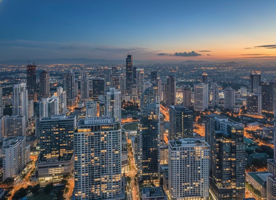
2. Taguig (BGC, Arca South)
Key facts:
- In the district of Bonifacio Global City (BGC), elevation reaches around 30–37 m above sea levelon McKinley Road and nearby areas.
- BGC benefits from advanced infrastructure — for example, a 12-metre-deep detention tank capable of holding 22,000 m³ of floodwater beneath Burgos Circle.
- The availability of a detailed 100-year flood hazard map for Taguig consolidates planning transparency.
Buyer-insight:
This area represents one of the strongest “flood-safe” bets inside the metro. For investors, higher price points are justified by stronger infrastructure and premium elevation.
3. Makati (Legazpi, Salcedo Village – elevated zones)
Key facts:
- Elevation mapping for Salcedo Village shows ~19 m above sea level, significantly higher than many flood-prone districts.
- Developers incorporating flood-resilience features: one example noted elevation of 7 m above sea level for podiums in a Makati riverside project.
- The location is removed from immediate river-flood zones and benefits from commercial infrastructure and premium accessibility.
Buyer-insight:
If budget allows, elevated Makati cores combine strong capital appreciation potential with modest flood risk. Still, check specific building foundation levels for the worst-case scenarios.
4. San Juan (Elevated villages around Greenhills, Little Baguio)
Key facts:
- Industry commentary identifies parts of San Juan (e.g., Little Baguio, Greenhills) as low to medium flood-risk, due to higher terrain and lesser exposure to major rivers.
- While formal elevation data is less widely published, San Juan’s topography places much of it on the Guadalupe Plateau ridge, linked to lower flood-susceptibility.
Buyer-insight:
Smaller city-footprint and higher-elevation locales make San Juan a smart alternative for buyers seeking established neighbourhoods with lower flood-stress. Infrastructure is older in parts, so check drainage upgrades.
Why This Matters for Your Real Estate Strategy
- Lower-risk zones reduce ongoing costs (flood insurance, repairs, premium rent discounts).
- They improve resale potential—buyers and tenants increasingly prioritise elevation and infrastructure.
- You still stay within Metro Manila’s convenience belt rather than moving to far-flung suburbs.
⭐ Comparative Table: High-Risk vs Safer Zones
| Zone Type | Example Areas | Typical Elevation* | Infrastructure Strength | Price / Risk Trade-off |
|---|---|---|---|---|
| High-Risk | Malabon, Navotas, southern Caloocan | ≤ 5 m above sea level | Often older drainage systems | Lower purchase price, higher mitigation & insurance cost |
| Moderate-Low Risk | Quezon City (higher zones) | ~10-100 m | Mixed (some modern) | Mid-to-high price, moderate flood risk |
| Premium Safe | BGC (Taguig), Makati cores | ~19-37 m or more | Advanced infrastructure | Highest price, lowest flood-risk exposure |
* Approximate; elevation above mean sea level.
How Flood Risk Affects Real Estate Decisions
Property Valuation: Flood-Prone Areas Often Depreciate Faster
Properties in flood-exposed zones carry an invisible “risk discount.” A global study covering 117 countries found that natural-disaster-prone areas tend to have lower house prices. Another empirical paper found that, when all else is equal, plots located in high-flood-risk areas suffer measurable price discounts. In the Philippines, research shows housing affordability is negatively impacted when flood-prone areas combine with poor transport access—meaning both price and convenience take a hit.
Actionable insight: Whenever you appraise a property in a flood-susceptible zone (e.g., near riverbanks or low elevation in Metro Manila), build in a contingency for potentially slower appreciationand higher holding cost. Factor this into your ROI model.
Insurance Costs: Flood-Prone Properties Require Higher Premiums
Insurance is a live cost, not just a future possibility. In the Philippines, the Insurance Commission has issued Circular Letter CL 2022-34 establishing minimum catastrophe (typhoon/flood) insurance rates, reflecting that flood risk affects premium structure. Globally, flood-insurance premiums are explicitly linked to elevation and flood‐zone classification.
Actionable insight: Before purchase, ask for recent insurance quotes for the specific address. If the premium is significantly higher due to flood-risk classification, it may erode your rental yield or resale margin.
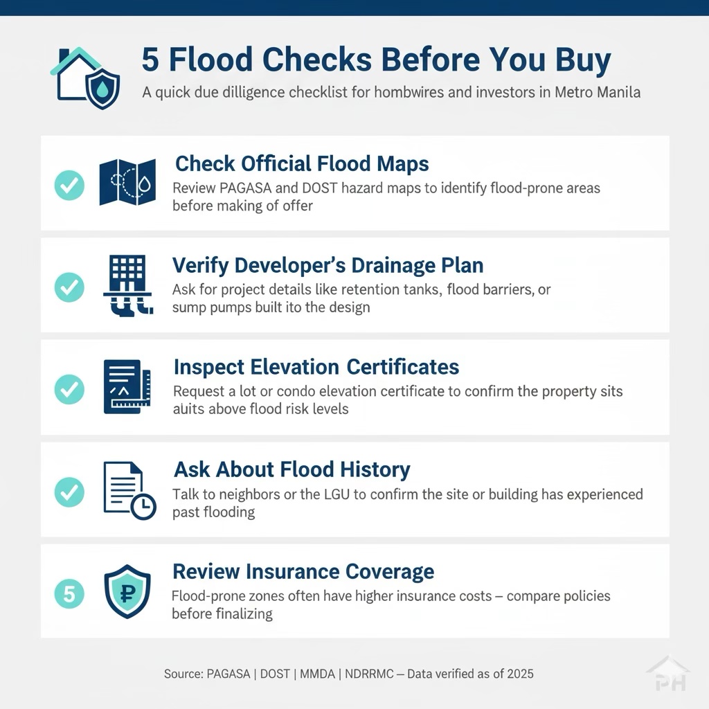
Due Diligence Steps — Your Flood-Smart Checklist
- Check official hazard maps — Use the Philippine Atmospheric, Geophysical and Astronomical Services Administration (PAGASA) flood-risk maps and municipal zoning/DRRM offices to verify if the barangay is mapped as high-susceptibility.
- Verify the developer’s flood-control design — Request documentation of retention tanks, drainage capacity, pump stations, raised podium or elevated floors. Don’t assume “new building” means “flood-safe.”
- Request an elevation certificate or flood-history report — Ask for the finished floor elevation above the base flood level, past flood-events (dates, depths) for the unit or neighbourhood.
- Stress-test your investment scenario — Assume a flood event occurs: What is the worst-case downtime, repair cost, insurance excess, replacement risk, and how will this affect your cash flow?
- Factor resale and liquidity risk — Areas known for flooding may attract fewer buyers, slower resale, and possibly stricter bank financing.
By applying these three lenses—valuation, insurance cost, and due diligence—you transform flood-risk from an abstract concern into a quantifiable decision factor. This gives you leverage. Not just to avoid costly mistakes—but to position yourself as a smart buyer in Metro Manila’s evolving property market.
Flood Mitigation & Smart Development Trends
Smart Drainage Systems in New Townships
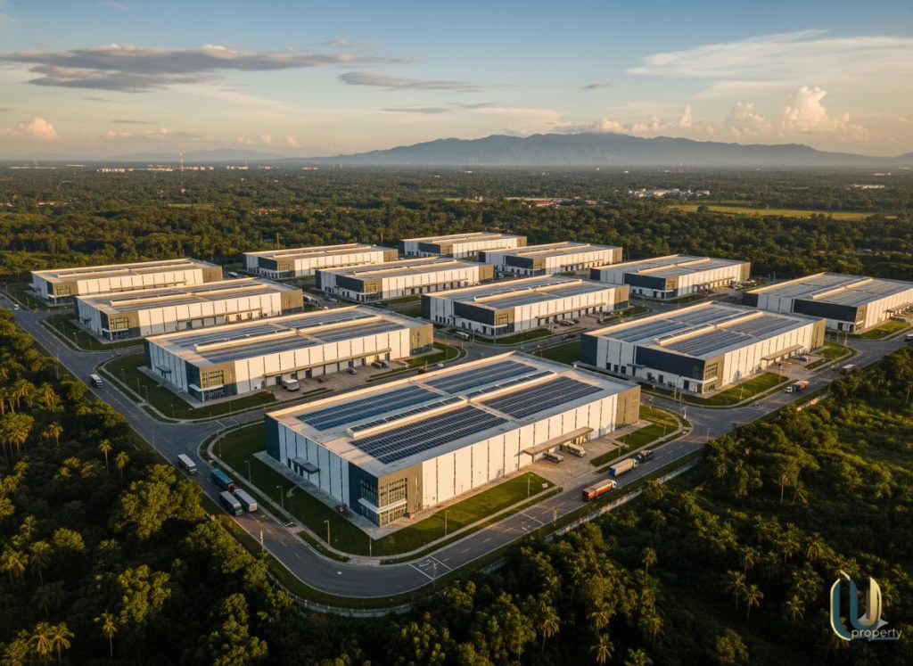
Urban drainage isn’t just about bigger pipes—it’s about smarter systems. Under the Department of Public Works and Highways-Metro Manila Development Authority (DPWH-MMDA) collaboration, the Metro Manila Flood Management Project supports a programme to modernise 36 existing pumping stations and add 20 new ones. This infrastructure upgrade anchors the drainage backbone of new developments in the region.
Developers are also integrating rainwater catchment basins beneath townships—holding thousands of cubic metres of runoff during storm events so the surrounding roads and homes remain dry. For example, one developer’s project achieved a catchment capacity of 85,400 m³, equivalent to over 34 Olympic-sized swimming pools.
Why this matters for you as a buyer/investor:
- Choosing a township with smart drainage means lower risk of flood-related downtime and potentially lower insurance costs.
- Such infrastructure is a selling point for future resale—“flood-resilient” = premium in the market.
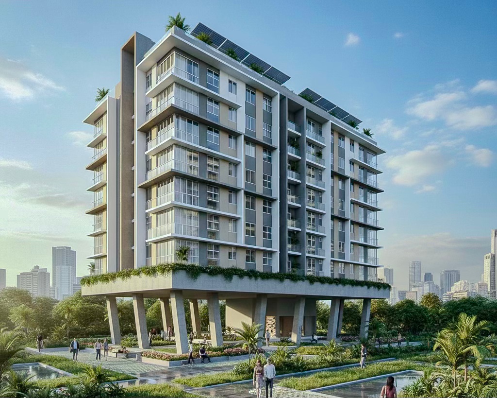
Flood-Resilient Condo Design: Elevated Podiums & Rainwater Solutions
The design frontier is shifting. Developers in the Philippines now put real “feet” under buildings—literally elevating structures and integrating water-management systems. For instance, one major developer’s structure near the Marikina River sits on 246 concrete stilts, allowing floodwaters to pass beneath the building—a design praised by the United Nations Office for Disaster Risk Reduction.
- Elevated podium car parks that double as temporary flood basins.
- On-site rainwater harvesting and retention tanks to control surface runoff.
- Use of higher finished-floor elevations above predicted floodlevels.
Buyer/Investor Action Step:
When inspecting a condo, ask the sales team:
- “What is the finished-floor elevation above the 100-year flood level?”
- “Is there a dedicated retention tank or raised podium design for flood mitigation?”
- “Has the project conducted a hydrological study showing flood-impact scenarios?”
These questions help you separate standard builds from truly flood-resilient ones.
Government Initiatives: Infrastructure + Master Plans
The national government and development partners are stepping up—but the challenge remains massive. DPWH, in collaboration with the Japan International Cooperation Agency (JICA), presented draft updated flood-control master plans for the Pasig-Marikina and Cagayan River basins in August 2025. For the entirety of Metro Manila, a comprehensive master plan backed by the Asian Development Bank (ADB) is scheduled for completion by 2026.
Government-led measures include:
- Desilting and dredging of major rivers and esteros to increase capacity.
- Modernisation of pumping stations in low-lying zones.
- Establishment of detention/retention basins in flood-prone barangays to reduce peak volumes.
What this means for the market:
- Areas targeted by these government programmes will likely see improved flood resilience over time—and hence value uplift.
- Buyers should check whether the property sits inside or outside the zone of planned infrastructure upgrades. Buying ahead of improvement can mean upside; buying behind might mean enduring risk.
Bottom-line: Flood risk is no longer just a deterrent—it’s an opportunity. By choosing developments and locations aligned with smart drainage systems, flood-resilient architecture, and confirmed government programmes, you position for resilience, premium value, and lower long-term risk.
Expert Insights & Buyer Tips
“The drainages in the metropolis are already outdated — the majority of drainage mains constructed dating back to the 1970s.” — Metropolitan Manila Development Authority (MMDA) acting chair Atty. Romando Artes.
“Flood forecasting is a key aspect in aiding disaster-risk reduction efforts… there’s a need to prepare this hazard by way of installing equipment and improving communication.” — Philippine Atmospheric, Geophysical and Astronomical Services Administration (PAGASA) Director Manalo.
“We see that natural disasters, including floods, retard development. A flood-stricken area must first be restored to normal before any development activity can be carried out.” — PAGASA educational materials.
These official statements underline a critical truth for property buyers: flood-risk is a real, measurable market and infrastructure factor—not just a weather nuisance.
Buyer Insight
“We lived in our old house in Marikina for 15 years without major floods. Then the 16th year came—and the gate was chest-high under water. That was when we sold and moved to a higher-ground area. Since then, flood-fear has become completely non-negotiable in our purchase checklist.” — Reddit user u/FirstTimeInvestorPH on r/phinvest.
This testimonial shows what seasoned buyers believe: the true cost of flood-risk isn’t just repair bills—it’s lost sleep, resale risk and emotional drain.
“What Smart Buyers Do Differently”
1. Elevate your due-diligence to flood-risk status
Don’t stop at “Is the title clean?” Ask: What is the elevation above flood-plain? What is the drainage design? Use official tools like HazardHunterPH.
2. Treat flood-exposure as a capital expense, not a passive risk
If a property is in a known flood-zone (see official LGU flood maps), assume higher
3. Look for infrastructure credentials in the property brochure
Does the developer mention elevated podiums, retention tanks, smart drainage? These are now value-add features—not just marketing fluff. (See references.)
4. Use official statements as negotiation tools
If the MMDA states the drainage is outdated, and that affects your area — you can use this as leverage on price or ask for developer/more LGU upgrade commitments.
5. Resist the emotional pull of “cheap land” in risky areas
A low purchase price in a known flood-prone zone often signals value discount rather than bargain. Re-price accordingly.
Tip: Before finalising any purchase contract, request a flood-history certificate from the barangay or LGU. Ask: “Has this site ever recorded > 0.5 m flood depth? For how long? After which typhoon?” If the seller cannot provide credible data or direction, flag it.
These expert viewpoints and buyer lessons turn flood-risk from a vague “maybe” into a strategic decision filter. Use them to build credibility when you advise clients, write content, or pitch property listings.
Conclusion
Flooding isn’t just a seasonal inconvenience—it’s a defining factor in property value, livability, and long-term investment success. Whether you’re buying a starter condo or a family home, understanding flood exposure gives you the power to negotiate smarter and invest wiser.
Key Takeaways for Metro Manila Buyers
- Flood maps are your first line of defense: Always consult PAGASA’s flood hazard maps or use HazardHunterPH before signing anything. They provide scientific, government-verified flood-risk data per barangay.
- Elevation equals protection—and value: Condos and homes in elevated or flood-mitigated zones (like BGC, Fairview, or Arca South) maintain higher resale and rental appeal, especially after major typhoon events.
- Don’t skip engineering due diligence: Ask developers about drainage systems, flood barriers, and catchment basins. Aesthetic architecture means little without resilient infrastructure beneath it.
- Flood risk impacts financing and insurance: Lenders and insurers adjust rates based on historical flood data. Buyers who understand this early can budget more accurately and avoid unpleasant surprises.
- Safer zones often yield stronger long-term ROI: Developers are strategically shifting new projects to elevated and flood-managed areas—a trend backed by DPWH’s Metro Manila Flood Management Project and LGU zoning reforms.
💬 Your Next Step
Thinking of buying in Metro Manila? I can help you identify flood-safe properties with strong resale potential and solid infrastructure backing.
📩 Message me today for a personalized consultation.


Leave a reply to The Dark Side of Real Estate in Metro Manila: Common Pitfalls and Risks – RichestPH Cancel reply